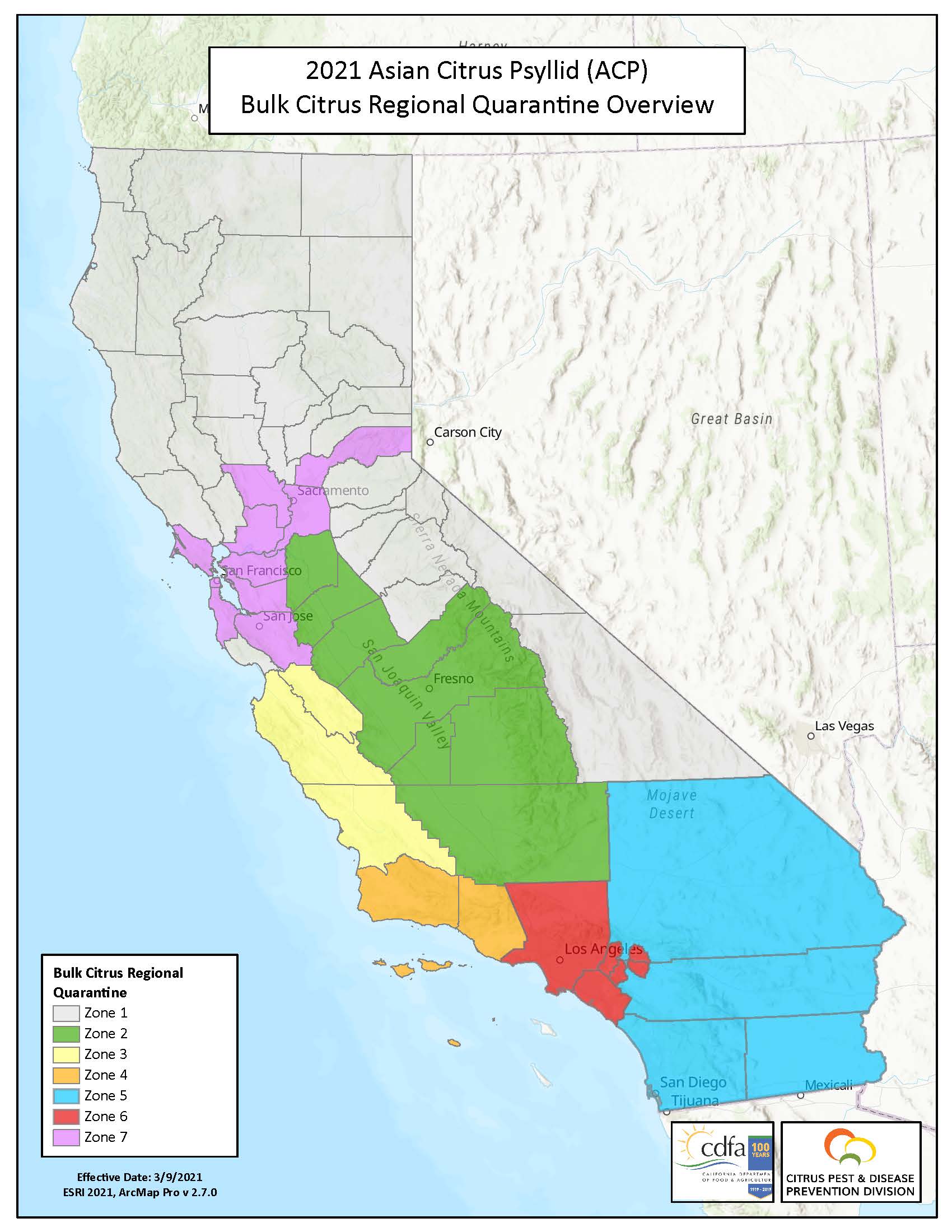
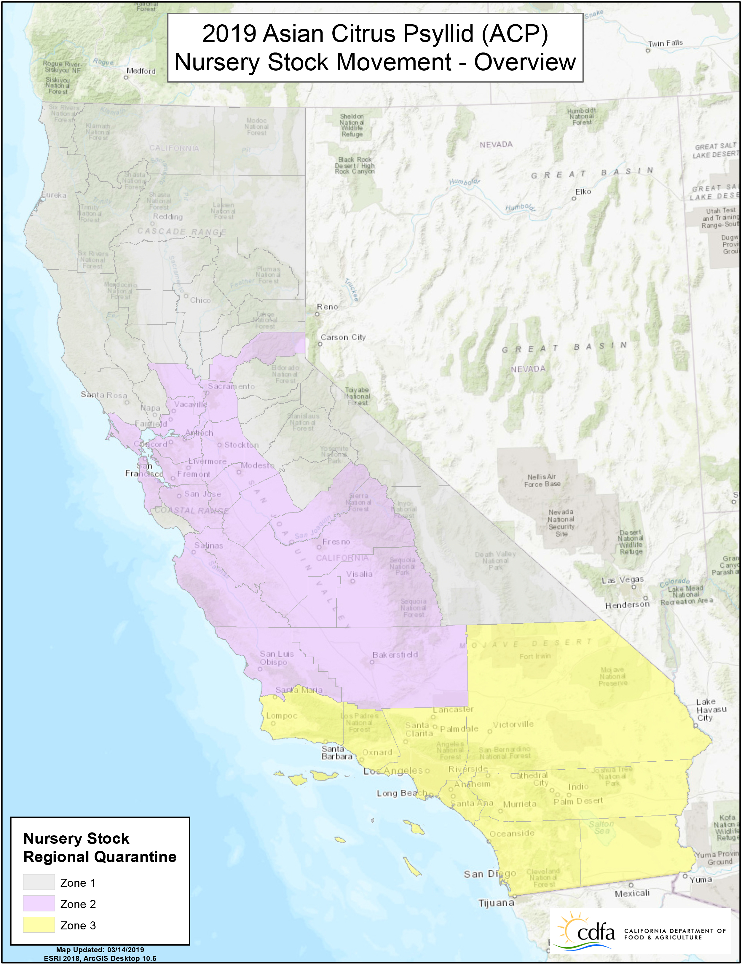
Zone 1: comprises uninfested counties where HLB has not been detected, there are no contiguous citrus growing regions, and it is not proximate to the border with Mexico.
- Zone 1 Counties: Alpine, Amador, Butte, Calaveras, Colusa, Del Norte, El Dorado, Glenn, Humboldt, Inyo, Lake, Lassen, Mariposa, Mendocino, Modoc, Mono, Napa, Nevada, Plumas, Santa Cruz, Shasta, Sierra, Siskiyou, Sonoma, Sutter, Tehama, Trinity, Tuolumne, and Yuba.
ZONE 2: comprises counties that are partially infested with ACP, HLB has not been detected, a geographical barrier exists between it and adjacent contiguous citrus growing regions (i.e., Zones 4, 5, and 6), a contiguous citrus growing region exists within the zone, sufficient citrus commodity cleaning and packing capacity exists within the zone, and geographical barriers separate it from zones that are heavily infested with ACP and where HLB has been detected (i.e., Zone 6).
- Zone 2 Counties: Fresno, Kern, Kings, Madera, Merced, San Joaquin, Stanislaus, and Tulare
ZONE 3: comprises counties that are partially infested with ACP, HLB has not been detected, a geographical barrier exists between it and adjacent contiguous citrus growing regions (i.e., Zone 2, 3, and 4), a contiguous citrus growing region exists within the zone, sufficient citrus commodity cleaning and packing capacity exists within the zone, and geographical barriers separate it from zones that are heavily infested with ACP (i.e., Zone 4) or where HLB has been detected (i.e., Zone 6).
- Zone 3 Counties: Monterey, San Benito, and San Luis Obispo
ZONE 4: comprises counties that are generally infested with ACP, HLB has not been detected, a geographical barrier exists between it and adjacent contiguous citrus growing regions (i.e., Zones 2, 3, and 4), a contiguous citrus growing region exists within the zone, sufficient citrus commodity cleaning and packing capacity exists within 8 the zone, geographical barriers separate it from Zone 6 where HLB has been detected, and it is not proximate to the border with Mexico.
- Zone 4 Counties: Santa Barbara and Ventura
ZONE 5: comprises counties that are generally infested with ACP, HLB has not been detected, a geographical barrier exists between it and adjacent contiguous citrus growing regions (i.e., Zones 4 and 6), a contiguous citrus growing region exists within the zone, sufficient citrus commodity cleaning and packing capacity exists within the zone, a geographical barrier separates it from Zone 6 where HLB has been detected, and it is proximate to the border with Mexico.
- Zone 5 Counties: Imperial and San Diego Counties, and a Portion of Riverside and San Bernardino Counties
ZONE 6: comprises counties, or portions of counties, that are generally infested with ACP, HLB has been detected in some areas, a geographical barrier exists between it and adjacent contiguous citrus growing regions (i.e., Zones 2, 4, and 5), a contiguous citrus growing region exists within the zone, sufficient citrus commodity cleaning and packing capacity exists within the zone, and it is not proximate to the border with Mexico.
- Zone 6 Counties: Los Angeles and Orange Counties, and a Portion of Riverside and San Bernardino Counties as described below.
In the Crestmore Heights and Riverside areas: Beginning at the intersection of the Union Pacific railroad tracks and the Jurupa Hills Country Club boundary at 33.972709 latitude and -117.444986 longitude; then, starting northerly along the Jurupa Hills Country Club boundary to its intersection with the intersection of Linares Avenue and Moraga Avenue; then, northerly along Moraga Avenue to its intersection with Avenue Juan Diaz; then, northerly along said avenue to its intersection with Peralta Place; then, northerly along said place to its intersection with Limonite Avenue; then, westerly along said avenue to its intersection with Camino Real; then, northerly along said real to its intersection with Granite Hill Drive; then, easterly along said drive to its intersection with the Sunnyslope City Boundary at 34.013533 latitude and -117.441269 longitude; then, easterly along said boundary to its intersection with Granite Hill Drive; then, northerly along said drive to its intersection with the Oak Quarry Golf Club boundary at 34.019669 latitude and -117.437699 longitude; then, northeasterly along said boundary to its intersection with the Riverside and San Bernardino county boundaries at 34.034006 latitude and -117.433997 longitude; then, easterly along said boundary to its intersection with Sierra Avenue; then, northerly along said avenue to its intersection with Sierra Avenue and Jurupa Avenue; then, easterly along Jurupa Avenue to its intersection with Alder Avenue; then, northerly along said avenue to its intersection with Santa Ana Avenue; then, easterly along said avenue to its intersection with Maple Avenue; then, northerly along said avenue to its intersection with Slover Avenue; then, easterly along said avenue to its intersection with Cedar Avenue; then, northerly along said avenue to its intersection with Valley Boulevard; then, westerly along said boulevard to its intersection with W Valley Boulevard; then, easterly along said boulevard to its intersection with S Riverside Avenue; then, northerly along said avenue to its intersection with E San Bernardino Avenue; then, easterly along said avenue to its intersection with San Bernardino Avenue; then, easterly along said avenue to its intersection with W Olive Street; then, easterly along said street to its intersection with Cypress Avenue; then, southerly along said avenue to its intersection with W C Street; then, easterly along said street to its intersection with N Rancho Avenue; then, southerly along said avenue to its intersection with W F Street; then, easterly along said street to its intersection with Pennsylvania Avenue; then, southerly along said avenue to its intersection with W H Street; then, easterly along said street to its intersection with E H Street; then, easterly along said street to its intersection with N Mount Vernon Avenue; then, southerly along said avenue to its intersection with I-10 E; then, easterly along said highway to its intersection with Hunts Lane; then, southerly along said lane to its intersection with S Hunts Lane; then, southerly along said lane to its intersection with E Washington Street; then, easterly along said street to its intersection with Sierra Vista Drive; then, southerly along said drive to its end; then, southerly along an imaginary line to its intersection with Prado Lane at 34.038381 latitude and -117.267737 longitude; then, southerly along said lane to its intersection with Utility Access Road; then, southerly along an imaginary line to its intersection with Scotch Lane at 34.023560 latitude and -117.263430 longitude; then, southwesterly along said lane to its intersection with Scotch Lane and at 34.021848 latitude and -117.263959 longitude; then, southeasterly along an Imaginary Line to its intersection with the Riverside/San Bernardino County line at 34.018800 latitude and -117.257880 longitude; then, southerly along an Imaginary Line to its intersection with Rattlesnake Ridge at 34.013657 latitude and -117.256658 longitude; then, southerly along an Imaginary Line to its intersection with an Unnamed Road at 34.007724 latitude and -117.257830 longitude; then, southerly along an Imaginary Line to 33.994941 latitude and -117.256701 longitude; then, southwesterly along an Imaginary Line to its intersection with Hidden View Lane at 33.986770 latitude and -117.263300 longitude; then, southerly along said lane to its intersection with Pigeon Pass Road; then, southerly along said road to its intersection with Climbing Rose Drive; then, westerly along said drive to its intersection with Barclay Drive; then, southerly along said drive to its intersection with Ironwood Avenue; then, westerly along said avenue to its intersection with Day Street; then, southerly along said street to its intersection with Gateway Drive; then, westerly along said drive to its intersection with Valley Springs Parkway; then, southerly along said parkway to its intersection with Eucalyptus Avenue; then, westerly along said avenue to its intersection with Eastridge Avenue; then, westerly along said avenue to its intersection with River Run; then, southerly along said run to its intersection with an Imaginary Line at the end of said run; then, southwesterly along said line to its intersection with Sycamore Canyon River at 33.9253452 latitude and -117.307673 longitude; then, westerly along said river to its intersection with an Imaginary Line; then, westerly along said line to its intersection with Barton Street at 33.925540 latitude and -117.313980 longitude; then, westerly along said street to its intersection with Cottonwood Avenue; then, westerly along said avenue to its intersection with Cottonwood Avenue and an Imaginary Line; then, westerly along said line to its intersection with Wood Road; then, southerly along said road to its intersection with Cannon Road; then, westerly along said road to its intersection with Alessandro Boulevard; then, southerly along said boulevard to its intersection with Berry Road; then, westerly along said road to its intersection with Crystal View Terrace; then, northwesterly along said terrace to its intersection with Overlook Parkway; then, westerly along said parkway to its intersection with Washington Street; then, northerly along said street to its intersection with Victoria Avenue; then, southwesterly along said avenue to its intersection with Madison Street; then, northwesterly along said street to its intersection with Arlington Avenue; then, westerly along said avenue to its intersection with Streeter Avenue; then, northerly along said avenue to its intersection with Rochester Street; then, westerly along said street to its intersection with Rexford Drive; then, northerly along said drive to its intersection with Central Avenue; then, westerly along said avenue to its intersection with Hillside Avenue; then, northerly along said avenue to its intersection with Mountain View Avenue; then, westerly along said avenue to its intersection with Sheppard Street; then, northerly along said street to its intersection with Jurupa Avenue; then, northerly along said avenue to its intersection with the United Pacific railroad tracks; then, northwesterly along said tracks to the point of beginning.
ZONE 7: comprises counties that are partially infested with ACP, HLB has not been detected, there are no contiguous citrus growing regions, and it is not proximate to the border with Mexico.
- Zone 7 Counties: Sacramento, Santa Clara, San Mateo, Alameda, Contra Costa, Marin, San Francisco, Solano, Placer and Yolo Counties


